MAKS / Address
GIS-Based Address & Numbering Management System
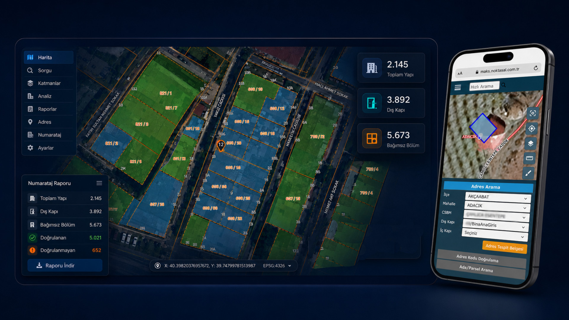
MAKS / Address is a GIS-based solution built for municipalities to manage address and numbering processes digitally. Neighborhood, avenue/street, building, exterior door, interior door and independent unit data are recorded, updated, verified and reported with map support. Aligned with the MAKS data model, the platform unifies data validation, duplicate checks, field control, QR-coded address documents, map-based query and internal integrations in a single system.
Standard, Current and Spatial Data Management for Address & Numbering
MAKS / Numbering is not just a registry. Municipalities verify address components on the map, update them from the field, manage them in line with MAKS standards and use them in institutional decisions.
MAKS-Compliant Data Model
Neighborhood, road, building, exterior door, interior door and independent unit records aligned to the MAKS data model.
GIS-Based Address Management
Address components are tracked, queried and verified spatially on the map.
Field Control & Updates
Field crews verify buildings, doors and independent units on-site, keeping data continuously up-to-date.
Reporting & Data Quality
Missing, wrong, duplicate or stale records are surfaced through reports to raise data quality.
The MAKS / Numbering Module Suite
The platform is modular — municipalities can digitise address and numbering processes step by step. Each module connects data creation, validation, field control and reporting into one integrated workflow.
Address Component Management
Neighborhood, road, building, door, unit.
Address & Numbering Management on the Map
Thanks to its GIS-based foundation, every address component is managed on the map. Neighborhood boundaries, road centerlines, building geometries, exterior door points and independent unit relationships are tracked spatially — so addresses are verified textually AND geographically.
Integration Infrastructure Aligned with the MAKS Data Model
The platform provides validation, change tracking, version-based updates and audit history so that data sent to or received from MAKS is controlled, traceable and reportable.
MAKS Data Model Compliance
All address components are produced in line with the MAKS schema.
Change Tracking
Who changed which record, when — fully traceable.
Version-Based Updates
Records are versioned; historical states are preserved.
Error & Log Management
Integration errors and audit logs are tracked centrally.
Data Validation Checks
Duplicate, missing or geometry-flawed records are caught automatically.
Internal System Integrations
Service-based integration with municipal applications.
Up-to-date Address Data with Field Crews
Field crews view their assigned building, door and address checks on mobile. They send updates back with location, photos and notes — keeping office records aligned with the real situation on the ground.
Today's checks
Building and door checks for the crew by neighborhood, street and status.
Location, photo & units
Geo verification, photo evidence and unit-level updates.
QR-Coded, Verifiable Address Documents
Municipalities can issue address documents at the door and independent-unit level. QR codes make verification simple — citizens, agencies and field staff can confirm an address reliably.
Address Determination Document
Officially templated, institution-approved address records.
QR-Coded Address Document
Fast, reliable verification through QR codes.
Exterior Door Document
Documents at exterior door number level.
Independent Unit Document
Documents at independent unit level.
Document Verification Screen
QR-loaded documents are checked on the verification screen.
Digital Archive
All issued documents stored in the digital archive.
Address Data Quality, Control & Reporting
Address accuracy drives many municipal services. The platform surfaces missing, wrong, duplicate, geometry-flawed or non-MAKS records — and executive dashboards make data quality and update performance visible across the organisation.
What MAKS / Numbering Delivers
Standard, Current Address Data
Address components are managed in a MAKS-compliant, relational and up-to-date structure.
GIS-Supported Verification
Buildings, roads and doors are verified on the map, raising data accuracy.
Seamless Field-to-Center Flow
Mobile field checks deliver the current situation to HQ quickly.
Reportable, Traceable Process
All changes, errors, gaps and updates are tracked on dashboards.
Other Solutions
NOYAS
GIS-Based Integrated Fire Department Information System
Manage every fire-department process — from incident response and reporting to fleet, training, inspection and digital applications — on a single GIS-based platform.
NOLEVS
Noktasal Sign Management System
A GIS-supported sign management platform that handles street and door-number signs end-to-end: requests, production, stock, field installation, maintenance and reporting.
NOTES
Noktasal Real Estate Inventory System
A modular real estate management solution that lets you manage your institution's property inventory geographically.